


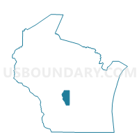
LINCOLN - T 1 Voting District, Adams County, Wisconsin
About
Outline

Summary
| Unique Area Identifier | 692186 |
| Name | LINCOLN - T 1 Voting District |
| County | Adams County |
| State | Wisconsin |
| Area (square miles) | 36.16 |
| Land Area (square miles) | 36.11 |
| Water Area (square miles) | 0.05 |
| % of Land Area | 99.85 |
| % of Water Area | 0.15 |
| Latitude of the Internal Point | 43.94441770 |
| Longtitude of the Internal Point | -89.64255340 |
Maps


Graphs
Select a template below for downloading or customizing gragh for LINCOLN - T 1 Voting District, Adams County, Wisconsin


Neighbors
Neighoring Voting District (by Name) Neighboring Voting District on the Map
- ADAMS - T 1 Voting District, Adams County, WI
- COLOMA - T 1 Voting District, Waushara County, WI
- EASTON - T 1 Voting District, Adams County, WI
- NEW CHESTER - T 1 Voting District, Adams County, WI
- PRESTON - T 1 Voting District, Adams County, WI
- RICHFIELD - T 1 Voting District, Adams County, WI
- SPRINGFIELD - T 1 Voting District, Marquette County, WI
- WESTFIELD - T 1 Voting District, Marquette County, WI
Top 10 Neighboring County Subdivision (by Population) Neighboring County Subdivision on the Map
- New Chester town, Adams County, WI (2,254)
- Preston town, Adams County, WI (1,393)
- Adams town, Adams County, WI (1,345)
- Easton town, Adams County, WI (1,130)
- Westfield town, Marquette County, WI (866)
- Springfield town, Marquette County, WI (830)
- Coloma town, Waushara County, WI (753)
- Lincoln town, Adams County, WI (296)
- Richfield town, Adams County, WI (158)
Top 10 Neighboring Place (by Population) Neighboring Place on the Map
Top 10 Neighboring Unified School District (by Population) Neighboring Unified School District on the Map
Top 10 Neighboring State Legislative District Lower Chamber (by Population) Neighboring State Legislative District Lower Chamber on the Map
- Assembly District 42, WI (57,978)
- Assembly District 72, WI (55,757)
- Assembly District 41, WI (55,581)
Top 10 Neighboring State Legislative District Upper Chamber (by Population) Neighboring State Legislative District Upper Chamber on the Map
Top 10 Neighboring 111th Congressional District (by Population) Neighboring 111th Congressional District on the Map
Top 10 Neighboring Census Tract (by Population) Neighboring Census Tract on the Map
- Census Tract 9504, Adams County, WI (4,767)
- Census Tract 9505.02, Adams County, WI (4,112)
- Census Tract 9605, Marquette County, WI (3,655)
- Census Tract 9604, Waushara County, WI (3,456)
- Census Tract 9601, Marquette County, WI (2,823)
- Census Tract 9502.02, Adams County, WI (2,674)